Georgian Bay—especially the 30,000 Islands region of its eastern shore—is one of the most intensively charted places you’re ever likely to find. It’s also one of those places in which boaters can quickly find themselves in plenty of trouble, by not understanding the rules that apply to navaids, wherever they happen to be. Even experienced boaters can get themselves turned around. If you’re in a powerboat, moving at planing speed, things happen fast in waters with little room for error.
My completely unscientific impression, after boating here for more than 25 years in a variety of sailboats and powerboats, is that people often tie themselves in navigational knots by losing track of which direction is “upstream” or “returning” as they negotiate the myriad navaids and channels in these shoal-infested waters. For those of you who might have forgotten the most elemental lesson in navigation where navaids are concerned, when headed in the “upstream” direction, the red navaids are starboard-hand, meaning they’re kept to your right. Green ones in turn are port-hand, and kept to your left. Hence the quickie memory aid, “red right returning.”
But how do you know when you’re “returning”? A very, very broad rule of thumb is that you are “returning” when you are moving into a harbour, which also tends to be upstream from any flow into the larger body of water. (I’m trying hard to think of an exception.) This rule-of-thumb can keep you out of most trouble, even if you don’t have a chart handy. And if buoys are paired, it’s not hard to figure out that you need to go between them. But there are plenty of cases in which it’s not clear on which side to pass: single lateral buoys that are set alone, without any obvious visual clues as to which side to pass them on, and channels that cross or diverge from other channels, to name but two. Even when you are sure you’re in an upstream (or downstream) channel, after running one for a while on a long passage a moment of inattention or confusion can suddenly make you wonder if the channel’s orientation has changed, especially if you have branched onto a secondary channel. All possible exceptions to obviousness are at play in southeastern Georgian, my home waters, which is also one of the busier places for commercial and recreational boating on the Great Lakes. It also doesn’t help that there are errors in digital charts that so many boaters rely on. For example, the dashed course line in Navionics passes on the wrong side of A66 near Hangdog Point, as I show in the screen capture below.

To make you more aware of when and where the navaids are telling you to follow the red-right-returning rule, I spent an afternoon doing screen grabs from the Navionics site for my local waters, and overlaying those grabs with arrows indicating the upstream routes. (To be clear, the arrows show the upstream direction, NOT the direction of the stream.) Needless to say, I expect you to do your own navigating, and not just follow my arrows blindly. But you can appreciate, even at a glance, how complicated and at times seemingly contradictory the upstream system can be.
If you think of your vessel, regardless of actual size or propulsion, as a freighter coming into Severn Sound (the main body of water south of Beausoleil Island), then the red-right-returning rule is fairly clear. Any vessel approaching the Sound from “outside,” beyond Hope, Christian, and Beckwith Islands and passing south of Giant’s Tomb Islands, is coming into port, and the navaids are arranged according to the red-right-returning rule of thumb.
Things get trickier where the small-craft route (described hereabouts in strip chart 2202, as well as in the regional chart 2241) is tossed into the mix. The small-craft route is laid out with the upstream passage (starting at the lowest mileage numbers) beginning in the southeast, and proceeding more or less northbound. For a boater heading north from one of the many local marinas, it’s easy to fall into the trap of thinking that outbound, everything is north = upbound = upstream = red-right-returning. That might often be the case, but it’s not always so in these waters.
The navaid system here has to reconcile the essential orientation of the small craft route (north = upbound = upstream = red-right-returning) with the reality that the upstream route that adheres to the logic of the main shipping channels is south = inbound = upstream = red-right-returning. A further complication arises from cross channels that can leave mariners momentarily wondering in which direction red-right-returning applies.
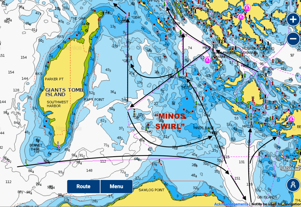
I’ve provided here two main views of the local red-right-returning paths. The first, focussed on the outer approaches, shows the basic freighter rule in play, of the inbound route that passes south of Giant’s Tomb Island and to the north of Sawlog Point on the mainland being upstream. Running counter to this orientation is the plethora of small-craft routes, all headed more or less north. In the middle of it all is a southwestward-running cross channel that runs from Whaleback Channel into the waters on the east side of Giant’s Tomb. This cross channel, which proceeds upstream to the southwest, gives you the option of then following two different courses, both upstream. One heads north to pass the north tip of Giant’s Tomb. The other turns south to create what I’ll call the “Minos Swirl,” a kind of back-eddy of counter-clockwise upstream motion. The important thing to remember hereabouts, when heading north, is that if you choose to follow the small-craft route on the east side of the Minos Bank, you’re going upstream, but if you decide instead to go west of the Minos Bank, the short, critical run towards M5 at Indian Belle Rock is downstream, and you don’t want to pass it on the wrong side.
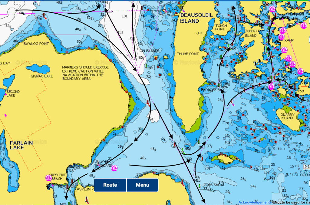
The second view takes us down into Severn Sound—or up into the Thirty Thousand Islands. The main shipping route, inbound, is southbound and upstream, and guides arriving vessels into either Penetanguishene Harbour or down towards Midland Harbour. Running counter to this orientation are the many branches of the small craft route. The tricky part is found in about three miles of water that lie between Gin Rocks, halfway up the west side of Beausoleil Island, and the waters between the south end of Beausoleil Island and Present Island.

The waters around the Gin Rocks are a transition point for vessels accessing the small-craft route. The green navaid (M9) off the Gin Rocks follows the southbound = inbound = upstream logic of arriving vessels, but it’s also here that northbound vessels accessing several options on the small craft route start thinking northbound = upstream. The real excitement is in the waters around Candlemas Shoal, at the south end of Beausoleil Island. There is a pair of navaids (M14, red, and M13, green) on the shoal’s west side, and the southbound = inbound = upstream logic applies. (There’s actually a lot of water immediately around them, just as there is around M9, and unless you’re a freighter, messing up here isn’t likely to ruin your day, so long as you stay away from Candlemas.) Just to their east is another navaid, MK1 (green), which is meant to keep you clear of Candlemas and the associated shallows off Beausoleil Island. (MK1 happens to be close to the wreck of the Wawinet, which I have written about in the blog. This motor vessel went down in 1942 with a loss of about two-dozen lives, and I am sure touched the shallows, which form a prominent bank, before heeling over, flooding, and going down.) If you follow the arrows, you can see the logic of how the southbound = upstream passage bends around the bottom of Beausoleil Island to become the northbound = upstream passage of the small craft route. The logic however isn’t necessarily clear to everyone, and I have seen at least one keelboat go aground here.

I include here a photo of the 1979 edition of 2202, showing two navaids west of Candlemas Shoal that were in the same colour orientation of today’s M14 and M13. (MK1 didn’t exist then.) But I also have a foggy memory of one or both of the pair of navaids to the west of Candlemas having for a time the opposite colour orientation, and that at some point the colour was switched back to the earlier configuration. (I tried looking up when this happened in NOTMAR’s searchable database of chart corrections for 2002, but nothing older than 2007 appears to be in the database.)
If nothing else, I hope this quick tour of red-right-returning around southeastern Georgian Bay conveys how complex the navaids system is. Anyone plying the waters of Georgian Bay needs to make a careful study of the charts before they plunge in. You need to understand how the many channels are oriented before you find yourself in them and wondering, at twenty-plus knots, which side of the fast-closing buoy you should pass on. And don’t count on the dashed course line of a digital chart or an app’s automatic routing options to figure it out for you.
Creating content for this site takes time and energy. If you find my efforts informative and helpful, consider becoming a supporter.
