

A guide to public and private lands for Ontario boaters
The rights of boaters (cruisers, kayakers, canoeists, anglers) where land is concerned in Ontario is a complex and often misunderstood subject, full of myth, half-truths and misplaced laws from neighbouring jurisdictions. I’ll try to sort out the main issues here as best I can. My focus is principally eastern Georgian Bay and the North Channel, but the information applies to pretty much any waterfront in the province.
Types of land
Land in the Great Lakes in Ontario comes in a several flavours, where boaters are concerned. There is private property of course, and then there’s a broad basket of public and quasi-public lands, federal and provincial Crown lands, which include parks and conservation reserves, and First Nations reserves that are either unceded (meaning the lands were never signed away through treaty by Indigenous peoples) or a special form of federal Crown land. Added to the mix are nature reserves held by land trusts, and conservation easements for which lands remain in private hands but some public use may be permitted.
Private land
For boaters, the most common type of private land encountered is a cottage property. Some private properties however have no discernible building on them, and never will, as municipal zoning or a restricted area order of the Ministry of Natural Resources and Forests (MNRF) will not permit a structure that requires a septic system. Some islands and islets are part of a greater private holding. Unless they’re clearly marked by signage, it’s not always possible to tell that a particular island or remote shoreline is in fact private.
Relations between cottagers and boaters range from benign to venal, depending on the area. To begin, boaters (and cottagers) need to understand that cottagers do not own the navigable water in front of their properties. And even if they own or lease the bed (which is provincial Crown land), navigation is protected as a federal right under the Canada Shipping Act. (A possible exception is Tadenac Bay on eastern Georgian Bay. The Tadenac Club, founded in 1884, feels it can legally seal the bay off from federal nav rights, but this is much disputed.) Anglers can troll right along the shore and up and down cottage docks, and cruisers are entitled to anchor out front, provided they do not fix the craft in any way to shore, or go ashore themselves. Provincial policy does extend to cottagers the right to build docks and install moorings for boats in navigable waters, so long as those structures do not interfere with navigation. Boaters similarly cannot anchor where they obstruct navigation.
Anchoring rights are dealt with in a separate article on this site. Some anchorages are notorious for friction between cottagers and cruisers. While we have some sympathy for cottagers on busy anchorages who have to put up with the loud antics of the occasional boating buffoon (which other boaters also hate), the anchoring rights enshrined under the Canada Shipping Act were there before their cottages were. The only complication is the rights cottagers may enjoy to forbid anchoring if they own the adjoining water lot, as I discuss in the anchoring rights article. But it should be clearly understood that a water lot is a tract of land that is submerged occasionally or is permanently submerged, and doesn’t include the water above it.
Perhaps the greatest source of misunderstanding is the concept of the “high water mark” being the lower limit of private property on shore. Cruisers sometimes cite this as a right to tie to shore, or to go ashore to walk, swim, light a barbecue, or camp on private land. But the legal concept of the high-water mark is far from clear in provincial law and may not even exist.
It derives from English common law, and has been used in many American states, under the Public Trust Doctrine, to shape some public right of access to shorelines. In Ontario however, the relevant legislation is The Bed of Navigable Waters Act of 1911. This act enforced the Crown bed of navigable waters as a provincial jurisdiction, but it was not clear how far that bed extended. In 1940, the provincial government amended the act to specifically describe the upper limit as being the high-water mark, but this amendment was struck out in 1951. Some case law preceding the 1940 amendment indicated that the low-water mark was in fact the limit of private property, and there is some opinion today that this is the case. However, the situation is far from clear. In 1998, the Ministry of Natural Resources issued a policy for its surveyors who were marking out Crown land for disposal. The policy stated that they were to measure down to the “water’s edge.” The “high-water mark” is used only in places where there is artificial flooding (ie. hydroelectric). But defining “water’s edge” is no mean feat, especially when water levels are constantly rising and falling. The issue of public rights and access to the shoreline is a burning issue in several areas of the province where there are major beaches, and is far from resolved.
The only shorelines with cottages that cruisers can unequivocally employ are ones that have a shoreline road allowance. These setbacks of reserved public land, usually about 66 feet wide, date back to the 19th century in Ontario, and were laid out in surveys to facilitate water travel. However, these allowances have been downloaded to municipalities, which have been selling them off to the adjoining property owners, and they are now few and far between.
I have heard boaters cite a notion of a right to go ashore for temporary activities such as cooking dinner. It doesn’t exist.
The bottom line for boaters in Ontario is that they should not go around citing the high-water mark as an upper limit on their activities. That right may not actually exist, and where there clearly is private property, attempting to use it is an unnecessary provocation.
Trespassing on private property
Ontario’s Trespass to Property Act (R.S.O. 1990, Chapter T21, last amended in 2016) encourages landowners to mark private property with signage, specifying that it is private and/or which activities are not be permitted. For example, a landowner may decide that he will tolerate hikers and other day-trippers, but forbid camping or hunting. Generally speaking, cottagers who want to keep boaters away from their land have installed the requisite signage. Some property owners are very generous in their accommodation of cruisers, kayakers and canoeists, but this should not be seen as a default position.
•Property owners can give notice on restrictions to access their property “orally or in writing,” which you should take to mean that if a property owner says “you can’t come ashore, this is private property,” you’ve been notified. An owner otherwise can give notice with signs “posted so that a sign is clearly visible in daylight under normal conditions from the approach to each ordinary point of access to the premises to which it applies.” Alternately, there is a specific marking system spelled out, using graphic representations that fit within a circle ten centimetres (about four inches) in diameter.
•Red markings indicate access is prohibited.
•Yellow markings indicate that entry is prohibited “except for the purpose of certain activities.”
• “A sign naming an activity or showing a graphic representation of an activity is sufficient for the purpose of giving notice that the activity is permitted and shall be deemed to be notice of the activities permitted.”
•“A sign naming an activity with an oblique line drawn through the name or showing a graphic representation of an activity with an oblique line drawn through the representation is sufficient for the purpose of giving notice that the activity is prohibited.”
Marking each and every island and islet as private or out of bounds to certain activities may not be practical, and we also think that a profusion of signage would be unsightly. The onus of knowing whether or not they’re trespassing is on a defendant if charges are laid. However, for trespassing to be enforceable in the courts, landowners need to make a reasonable effort to erect and maintain proper signage. If you innocently make use of land that turns out to be private and are asked to vacate, hopefully you can retreat gracefully while suggesting for everyone’s sake that the property be properly marked according to the Trespass to Property Act.
Regardless of the nature of the land you use, leave it in the same condition in which you found it. If you leave garbage and beer empties in someone’s backyard, they’re unlikely to invite you back, and where cruisers are concerned, everyone suffers when one boater is a slob or leaves a fire carelessly smoldering.
There is a concept of “historic use” in provincial law, which has been used to allow the public to continue to occupy or transit certain private lands, through what is called a prescriptive easement. But there would have to be a demonstrable, longstanding tradition in this regard for someone to claim such a right, and even then, it’s probably headed to court if the landowner really objects.
A worthwhile parallel situation for cruisers to consider is hunting rights. Hunters in Ontario cannot enter or cross private property, even to get to public land, unless they have the landowner’s permission. The onus again is on the defendant where there is an accusation of trespassing. Landowners are encouraged to post signs that specifically say no trespassing, or have a symbol indicating no hunting is permitted.
The Southern Georgian Bay O.P.P. advised landowners during the fall 2009 hunting season, “Private property owners, who do not wish persons to enter upon their property, must properly sign the property. In order for the provisions contained within the Trespass to Property Act to be enforceable, property owners at a minimum, must post a sign that has a red dot on a white background. Signs that clearly state `No Trespassing’ are readily available at most hardware type stores, are inexpensive and carry a very clear and concise message. The simple posting [of] a single sign on a large piece of property may not be enough (for court related purposes) and signage should be placed at regular intervals along the property line it is designating as private. The signs should also be checked on a regular basis to ensure that they are still posted, clearly visible and in good repair.”
Trespassing is usually linked to the broadly defined activity of “occupation.” That doesn’t only mean building a shack or setting up a campsite. Going ashore with a portable barbecue or to light a campfire is an act of trespass. Most important for cruisers, once you tie a line to a tree or set an anchor ashore in the ground or between exposed rocks, you are “occupying” that land. That’s how Ontario’s Ministry of Natural Resources and Forestry (MNRF) defines occupation of Crown land, including parkland, which we’ll get to shortly. You can think of the rope-to-shore situation as the “hammock law.” If I string up a hammock by using a tree on my neighbour’s lawn, or the downspout on his eavestrough, he’s going to consider that trespassing, even if while lying in my hammock I’m physically suspended over my own property.
Trespassing on Public Land
Just because land is in some manner in the public domain doesn’t mean you have unfettered access to it. Certain kinds of federally or provincially owned land (above and beyond the restrictions spelled out below) can be posted against trespassing for reasons of security or safety. National Defense properties are an obvious example. (Good luck going ashore at the tank range in Meaford.) Coast Guard properties can also be posted, as eleven Torontonians in two boats discovered in 2009. Responding to a report of a possible break-in at the unmanned lighthouse on Brébeuf Island on the west side of Beausoleil Island in southeastern Georgian Bay, the OPP found the group having a picnic in defiance of no-trespassing signage on the island. All were charged under the Trespass to Property Act.
Crown land
Crown land is public land that belongs to the nation (as opposed to public lands that are municipal holdings), and comes in two broad administrative flavours in Ontario. Federal Crown land includes national parks, First Nations reserves, and Crown islands on eastern Georgian Bay south of Moose Deer Point. The rest of Crown land is provincial. There’s a tremendous amount of Crown land of all kinds on Georgian Bay and the North Channel.
Whether federal or provincial in nature, some of these public lands are categorized as unalienated Crown lands. They are Crown lands that have no particular administrative definition. Unless otherwise posted, anyone can camp, go ashore, or tie to unalienated Crown land without authority or permission. Generally speaking, these are federal Crown lands not included in a national park, and provincial Crown lands administered under the Public Lands Act.
Other provincial Crown lands are formally defined as provincial parks or conservation reserves, under the authority of the Provincial Parks and Conservation Reserves Act, and are administered by the Ministry of Natural Resources and Forestry.
Anchoring rights in provincial parks is discussed on my anchoring rights page. Suffice to say that navigable waters in and around parks and Crown land (and any other sort of land, for that matter) are free for cruisers to use. But the moment you tie a line to shore or go ashore, you are “occupying” Crown land. In the case of a park (federal as well as provincial), you should expect to have to pay a user fee in doing so. It’s not always practically possible to do so, but cruisers who regularly make use of Georgian Bay Islands National Park, which is federal Crown land, are known to “do the right thing” and purchase a season’s pass for their dinghy for going ashore.
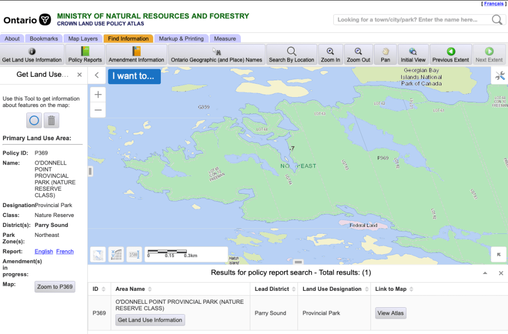
Provincial Crown land is subject to a variety of permitted uses. The best resource for eastern Georgian Bay and the North Channel is online at Ontario’s Crown Land Use Policy Atlas. The map is scalable and very detailed, but I recommend de-selecting “private land” (under Crown Land Use Data) because for some reason that layer sometimes obscures park areas. If you click on the “find information” tab and choose “get land use information,” clicking on the map on a location that interests you will call up the relevant info. (The interface can be sticky. It’s sometimes easier to key in the policy ID label on the map, for example, P369 to learn more about the lands in O’Donnell Point Provincial Park.) It will tell you if it’s private land, for example. If it’s some kind of public land, it will provide a link to a detailed report, in French or English, with guidance on where to find permitted uses.
The Crown land from Pointe au Baril north to Henvey First Nation, for example, is mainly designated as C117, which since 2006 has had a recommendation (unrealized) to become the North Georgian Bay Shoreline and Islands Conservation Reserve. Co-management with First Nations is contemplated, possibilities of sale for private use are few and far between (and don’t include new cottage properties), and there’s nothing to prevent you from going ashore or camping, for now.
Another designation you’ll come across, shown as yellow on the GIS map, is G359, a “multiple resource management” designation in Parry Sound district. “Crown land recreation” is permitted. This land has more possibilities for private future use than C117, although sales for new cottages isn’t among them.
The “land use intent” description for G359 says the designation is meant:
To provide and encourage provision of a wide variety of resource production and recreation opportunities.
The disposition of public land for development including public land on Georgian Bay, for purposes other than cottaging and recreational hunting/angling camps may occur providing:
– land of similar capability, suitability and site characteristics is not available privately;
– disposition will not result in competition with the sale of private land for similar purposes or depress the market value of private land in the district;
– disposition will not result in restrictions on adjacent resource use;
– disposition is consistent with official plan policies and will meet the requirements of zoning by-laws; and
– disposition will complement private land development.
Other map resources
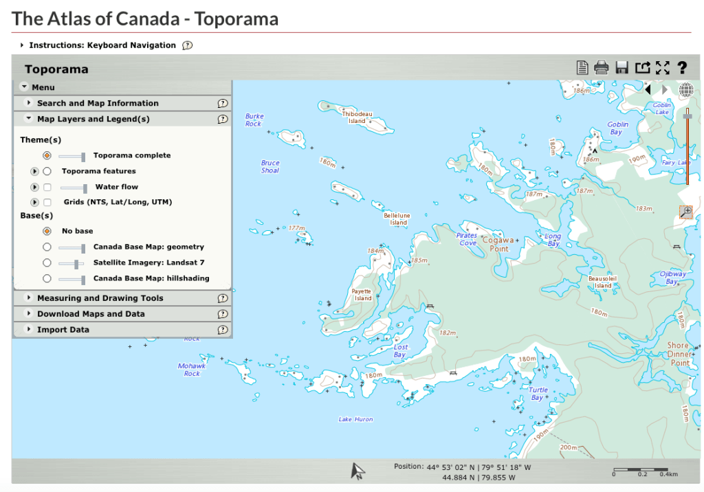
I used to advise investing in paper topographic maps for cruising areas. These don’t show land use or ownership (beyond park locations and boundaries), but they do include building structures. But the information can be out of date. There’s also Toporama at The Atlas of Canada, maintained online by Natural Resources Canada. You can zoom in on any location in Canada and print the results. You can also generate maps at Ontario’s Ministry of Environment and Energy. Comparing the two tools for northern Beausoleil Island shows their relative strengths and weaknesses. Toporama gives you helpful stuff like structures, while Ontario’s tool shows trails on Beausoleil Island.
For detailed delineations of properties, showing boundaries and types, check out the online GIS resources of various townships, for example the Georgian Bay Township zoning map, which covers properties along the bay from Port Severn to Twelve Mile Bay. The District of Muskoka’s online topographic resource also does an excellent job of delineating various property types and clearly labels park holdings.

Leading online map resource, like Google Maps and Apple Maps are quite good for showing structures. They can also display local trails.


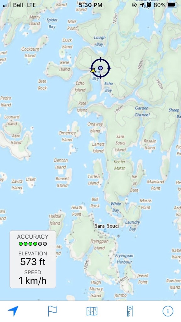
A great (free!) app is Topo Maps Canada, which I run on my iPhone. Available from the App Store, this amazing tool from developer David Crawshay (whose LinkedIn profile says is a senior software architect at Halliburton in Houston) uses official 1:50,000 topographic maps in several options that you can download at no charge. (There’s also a free Topo Maps US version.) In addition to displaying your position using your phone’s GPS, the app allows you to create and save trails by “painting” your movement, measure distances, and see your elevation changes as you move through the countryside. A great tool for when you’re hiking ashore.
Land Trusts
Cruisers may find themselves in the vicinity of islands and other shoreline properties held in trust by the Nature Conservancy of Canada and the Georgian Bay Land Trust. These areas are not specified in the Crown Land Use Policy Atlas. You can visit the Georgian Bay Land Trust website to see a complete list here. “Green” properties allow public access; “yellow” ones require owner permission and “red” ones are entirely off limits. These holdings have been preserved from development because of their unique and sometimes threatened ecological qualities. It goes without saying that those qualities should be respected by boaters.
First Nations Reserves
There are a number of major reserves around Georgian Bay and the North Channel. They are designated and administered under the federal Indian Act. As such, they are federal Crown land, although there are exceptions. Wiikwemkoong Reserve 26 on eastern Manitoulin Island for example is an unceded territory, as the band has never surrendered land by treaty, and the band also owns land at Point Grondine on the east side of Beaverstone Bay. (See the discussion of their land claim below).
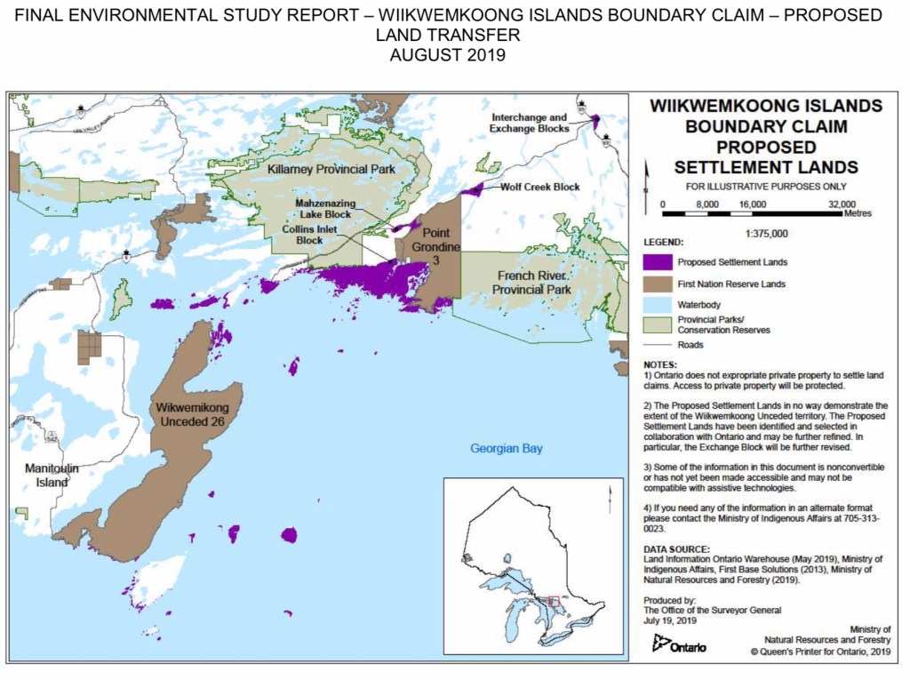
One of the largest reserves encountered by cruisers is Reserve 2 of Henvey Inlet First Nation, which stretches south along the east shore of Georgian Bay from the Key River to just north of Britt, and includes such cruising grounds as Henvey Inlet, Sandy Bay, and part of Black Bay. It’s important to realize that while the mainland in this area is part of the reserve, the islands are not. They’re either private property or provincial Crown land, as the case may be. There is an outstanding land claim, submitted in 1997, by the Wiikwemkoong Unceded Territory, for islands along the North Channel from just east of Sault Ste. Marie, all the way down the eastern shore of Georgian Bay to O’Donnell Point. A 2019 proposed settlement involves a number of islands in Georgian Bay close to the unceded reserve’s current lands on eastern Manitoulin Island and Point Grondine, as well as Philip Edward Island and some nearby lands (see the map). Cottagers around Collins Inlet, which is on the main block of the proposed settlement lands at Philip Edwards Island (but which does not involve any transfer of cottage properties), are vigorously opposed. As well, Wasauksing First Nation has been negotiating with the province since 1981 for the title to several islands adjacent to the reserve on Parry Island, near Parry Sound. Resolution of the claim requires Canada and the First Nation to initial and sign a Boundary Clarification Agreement.
Trespassing on reserves is covered by the Indian Act. Under it, “occupation” can be interpreted as broadly as the MNRF does with respect to provincial Crown land. Tying a line to shore, rafting along a rock wall, and other activities like camping and campfires and barbecues could be considered a form of occupation. (If some stranger held a cookout on your front lawn, you’d probably call it trespassing, too.) Beausoleil First Nation, whose Reserve 30 encompasses Christian, Hope, and Beckwith Islands, charges a fee for coming ashore and using the popular cruising beaches, but has also been requesting an anchoring fee, as I discuss in my anchoring rights story. Prosecution of trespassing on a reserve is up to the discretion of a reserve’s band council. In our past experiences cruising in the Henvey reserve area, we were never approached and asked to remove ourselves from reserve land. But it remains entirely up to individual bands to decide if they want to define routine cruising activities as a form of trespassing.
—Copyright Douglas Hunter. Reproduction or reuse in whole or in part is not permitted without his expressed permission.
This article is a work in progress. Last updated October 5, 2021.
Comments? Suggestions? Send them here.
Creating content for this site takes time and energy. If you find my efforts informative and helpful, consider becoming a supporter.
